In the year 1700, various maritime instruments were available to assist a Ships’ Master in setting and keeping a course but Navigation was not yet a science and still very much an art in the form of ‘an informed guess’. The basics of navigation were taught ashore in what was described as ‘river discipline’ (i.e. before you went to sea) but it was always conceded that this was no substitute for actual experience at sea. Disasters - in the form of ships or even fleets of ships being lost - were not uncommon.
The basics of maritime navigation involve simple calculations based on information about the speed of a vessel and the direction in which it is heading. ‘Plain sailing’ can be plotted in it’s simplest form as follows : using your compass, note which direction the ship is traveling from a known position such as a harbour or a port and any necessary changes in direction at the wheel or tiller. Using the ‘log-line’, measure the speed of the ship each hour. After twenty-four hours, you will have enough information to plot a position on a chart (should you have one). This information plotted on a chart will show the location of your ship upon it, and you can calculate using basic tools how long it will take you to reach a nearby destination and in what direction to sail to reach it. This is named ‘Deduced Reckoning’ in terms of position. But - of course it isn’t as straightforward as that and if it was as simple as this, anyone would be able to do it !
A navigator needs to be literate - to be able to read and write to some degree in order to keep records of where the ship is at any one time. He may or may not have a chart - in 1700 charts were slowly becoming more widely available - but the information on any of these charts was not necessarily accurate and wide areas of the globe still remained uncharted. Currents, the tide and the wind also affect a ship in motion - in simple terms, the ship would also be moving ‘sideways’ to some degree and if you didn’t allow for ‘leeway’ in your calculations you will never plot a true position. The wind direction always decrees which direction your ship would be able to sail in - which might not be the direction you actually want to sail in! To reach some destinations you would have to plot a course to suit the prevailing wind which on a chart would be seen as a series of ‘zig-zags’ rather than as straight line. Long voyages made over months would have to allow for the fact that Time is not a constant - any drop in wind or any other unseen hazard would mean that your anticipated arrival time cannot be declared with accuracy : in some cases, an estimate of an arrival would fall between two dates sometimes spanning several weeks rather than several days. If your ship ran out of food and water because of this - you will die !
Navigation is closely tied in with ‘anticipation’ - your ship can’t go backwards (not without risking serious damage anyway) and unlike a motor vehicle a ship is not fitted with brakes. Staying close to the coast would engender more accurate navigation especially if you had a map or a chart - but a trans-Atlantic voyage and of course, into ‘uncharted waters’ - negates this possibility. The coast itself involves dangers such as ‘shoal water’ (shallows) and of course, rocks and reefs. The onshore breeze and tide would make being caught on a ‘lee shore’ extremely hazardous if your ship could not get clear to windward - if you had to anchor to prevent being blown ashore if your anchors then dragged in a strong wind, your ship will be wrecked and you can do absolutely nothing about it ! As a pirate, by staying close to a coast or an island, in a regular ‘sea-lane’ or near a location commonly used by shipping, you would seriously limit your operational area and sooner or later ships would avoid that spot - and you would also attract the attention of the Royal Navy or a Spanish coastguard with the intention of capturing your ship or simply blowing it out of the water. In open sea, how could you check your ‘plain sailing’ or ‘Deduced Reckoning’ was correct ? You really need two references - a plot north-south in terms of LATITUDE and a second plot east-west in terms of LONGITUDE ; where the two lines ‘crossed’ that would be your actual position. You could do this by using instruments, of which in the year 1700 two main forms were available : latitude can be calculated by ‘observing’ and measuring the height above the horizon of the sun at noon (the ‘altitude’ angle) - and by keeping track of Time you can calculate your longitude.
LATITUDE
Three forms of instrument were available in 1700 to ‘observe’ the sun at noon; the time the sun was highest in the sky. Once you’ve used an instrument to measure the altitude of the sun, ‘nautical tables’ printed in an almanack could give you your latitude so you’d then be able to draw your north-south line on your chart and if you were reasonably skilled probably accurate to somewhere between ten and fifty nautical miles of your actual position north-south.
LONGITUDE
To calculate longitude, you need to know the time of the port you sailed from and the time at the point you are currently at - the sun moves 15 ° to the west every hour every day, so in simple terms if you sailed from London and from your ‘nautical almanack’ you knew that the sun rose in the east in London at 6.00am on the calendar date your ship is on but viewed from your ship on that date the sun rose at 8.00 am on the same date, you would know that you were 30° to the west of London ( 2 hours x 15°) and that would give you your east-west line. But - and this is the great ‘stumbling block’ in the year 1700 and would remain so for another seventy years until the invention of a reliable mechanical clock - Longitude is governed by Time and the only ‘clock’ you would have aboard ship to maintain the time in London would be a sandglass. You could ascertain ‘local time’ by using your compass and the sun - but if anyone forgot to turn the sandglass that was recording London time or even if they did remember and the sandglass was running just one second an hour wrong over just a few days your longitudinal calculations would become seriously wrong and using them for positional reckoning useless (you could be as much as 250 miles in error within just one week). Of course, navigation was undertaken aboard both merchant and pirate ships : but the more skilled you are and the more reliable your instruments were and the less rum you drank - and the more navigators there were aboard the merrier, as they could all compare their individual calculations daily to ascertain a ‘mean average’ - hopefully you then have something like a true position of the ship. A Royal Navy fleet of five ships after twelve days at sea in fog sought ‘a mean average’ from all their navigators in October 1707 which later resulted in four of the five ships running onto rocks near the Scillies and two thousand seamen drowned…
Using Early 18th Century Navigational Instruments…
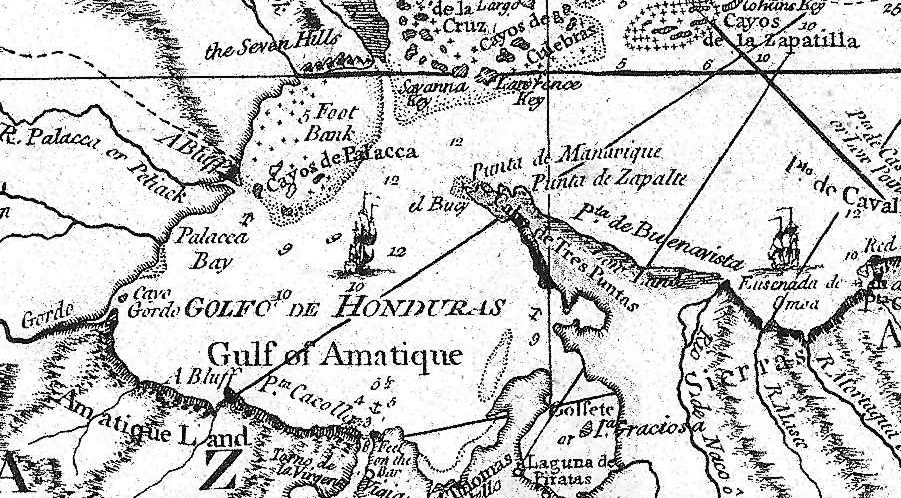
A small section of an original chart used by the Captain in educational sessions all over the UK. The idea of this navigational exercise when demonstrated is to bring the vessel in the Laguna de Piratas (lower centre) ‘safely into port’ using the information supplied, the chart and some basic instruments. The tiny numbers show the depth of water at low water in ‘fathoms’. |
As you may have already gathered, very basic instruments deal with measuring speed and direction and some means of keeping a record of these and any changes. A ‘logbook’ and a pencil would enable a navigator to keep records if he could read or write : other than that, in some form of scribbles or scratchings that he could understand when referring back to. Pending his individual skill, he could make his own chart as he sailed by taking bearings on any coasts seen. A compass will tell you in what direction you are sailing in relation to Magnetic North (which is not the same as the ‘True North’ you would plot if you chose to use the stars to navigate). Compasses came in many forms and sizes - a variation is the ‘Bearing Compass’ used for taking sights of coastlines or other landmarks such as rocks or reefs.
A ships’ speed needs to be measured quite often (at least every 30 minutes when under way as the wind that is driving your ship will rise or fall in strength and speed increase or decrease in the same way). To do this one can easily create and use a ‘log-line’ (which will also give an idea of ‘leeway’ the vessel is making) : there is a simple equation between how fast a line tied to an object in the sea pays out from a ship as the vessel moves away from it - using a sandglass as the log-line pays out from a spool, a navigator can calculate how fast the ship is moving in terms of nautical miles per hour (or as this became known, ‘knots’). As a navigator has to eat and sleep sometime, the job of taking these notes would be shared with at least one other person on an ‘alternate watch’. Without making these notes, you will never know - to within several hundred miles on a long voyage - roughly where your vessel is on a chart (if you had a chart).
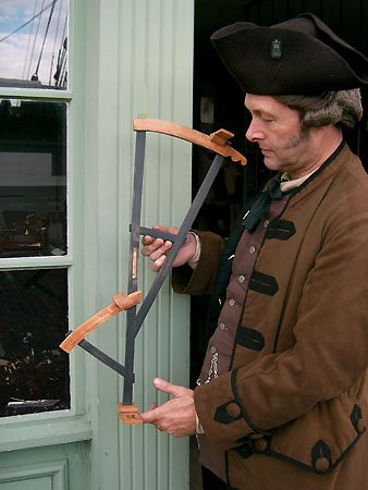
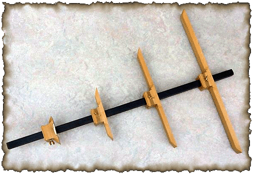
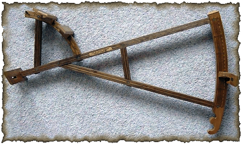
What happens if you are unsure where you are - lost ! - or when after a storm your ship is blown some way off course ? You can always make an ‘educated guess’ here but if you are wrong you may pay for an error with your life and those of the rest of the crew, so the capacity for must be reduced as much as possible. You can see from the above that Latitude can be calculated from the deck of a ship using an instrument to measure the height of the sun in the sky : many positions in the early 18th Century are given in latitude only because of the problem in calculating Longitude - this necessitated the logic of sailing north or south until you reached the ‘parallel of Latitude’ your destination actually lay on then steering east or west until you reached it. Without going into too much detail, the height and position of the sun (or other celestial bodies) for every day of the year including allowances for seasonal variation were printed in ‘nautical almanacks’ which by 1700 were widely available. He would still have to be recording ‘calendar time’ to fix a date, but if he had an instrument such as The Cross-staff or The Davis Quadrant and knew how to use it correctly, an observer aboard ship can fix the height (altitude) of the sun at noon and take off his reading from tables printed within the almanack (you can do this without tables but the calculation is a tedious one). Having fixed his latitude, he would then know his east-west position on a chart or relative to the given latitude of a destination or a home port - but - some ‘guesswork’ still remained in him fixing a position on the east-west line as in fixing longitude before the introduction of a reliable maritime key-wound clock in the latter half of the 18th Century, performing a set of very complicated calculations lie before him (and these calculations took some hours and would be beyond all but the very skilled navigators).
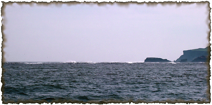 Navigation has always been closely associated with seamanship. The large rocks seen here (centre-right) are just over a mile away from the point where this photograph was taken ; in the centre foreground are ‘breakers’ over an extensive submerged reef lying a mile offshore. Even after charts showing this hazard became available several ships were still wrecked on these rocks when ‘standing in’ and despite updated charts, several warning buoys and a nearby lighthouse these rocks are still a major navigational hazard today. When charting the unknown east coast of Australia in 1770, HM Bark Endeavour ran onto just such a submerged reef well out to sea and suffered serious hull damage - though handled by a very skilled Captain and a very efficient crew they narrowly managed to avoid the total loss of the ship. Authors Collection |
The reader may be thinking that arriving roughly at a destination is perhaps enough ( perhaps then thinking to send a boat ashore to ask for directions from someone ! ) but arriving just twenty miles downwind from your destination could then see you spending a week ‘beating upwind’ to make port and many destinations for pirates were islands - and some relatively small islands at that - not lengthy coastlines. At least three occasions are recorded in pirates ‘missing’ islands they were sailing for and then wasting a long time trying to find them !
Pirates often stole not just ships and cargo but members of a ships’ crew and the master or a skilled navigator of a prize - along with his charts and instruments - would be a primary target for any pirates !
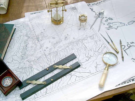
Approaching
the end of a voyage - the final chart in a ‘theoretical’ 4000 mile sea-voyage
made by a ship in the year 1700 from Bristol to Jamaica then on to Honduras to ‘drop
anchor in search of buried treasure’. The reality time-scale was ‘adjusted’ and
an eight-week voyage in real-time actually took just over one hour … including
being attacked by pirates and running aground on a sandbar at night off the
coast of Ruatan ! A simple ‘have-a-go’ maritime
navigational exercise presented by the author (who played the part of the
‘prevailing wind strength and direction’) conducted by local schoolchildren for
educational purposes. Only ‘chartroom’ tools are seen here : small and
large-scale 18th Century charts, parallel rule, ‘boxed’ gimbal compass,
logbook, sandglass, chart-reading glass, dividers, a ‘mechanical’ pencil - and a magnifying glass to find the actual destination. The
‘buried treasure’ turned out to be a bag of gold coins … made of chocolate. |
The captain would like to expess his great thanks to Richard Rutherford-Moore, for many hours by candle light teaching me all I needed to know about navigation, and allowing us to use the above content from his book "The Pirate Round"
|